
Research
Our research aims to transform urban energy infrastructures into digital, intelligent, and efficient systems that foster sustainable and resilient cities. To achieve this, I adopt an interdisciplinary approach that integrates Machine Learning, Geoscience, IoT, and Renewable Energy Technologies.
Generative AI-Enhanced Heterogeneous Geospatial Database Development
Keywords: GenAI, LLM, Data Analytics
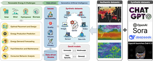
The integration of Generative AI (GenAI) and Large Language Model (LLM) with heterogeneous geospatial data to address critical challenges in renewable energy systems. The goal is to build intelligent, multimodal geospatial databases that support data-driven decision-making across the renewable energy lifecycle.
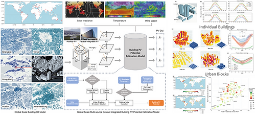
Global-Scale Mapping of Urban Renewable Energy Sources via Remote Sensing and Machine Learning
Keywords: GIS, DL, Pattern Recognition

Explore a comprehensive framework that integrates multi-source remote sensing (RS) data with advanced machine learning algorithms to enable the global-scale mapping and analysis of urban renewable energy sources.
Spatial-temporal Renewable Energy Evaluation and Validation for Sustainable Development
Keywords: 3D-urban, Low-altitude, Sustainability
Develop a real-time and global-scale spatiotemporal evaluation framework for urban renewable energy by integrating 3D urban environment, climate datasets, and physical models.
Renewable Energy Simulation and Digital Twin Toolkit Integration for Smart Energy Infrastructure
Keywords: Digital Twin, Toolkits Dev.
By combining environmental data, building-level modeling, and digital twin technologies, the study enables dynamic simulation and optimization of urban solar and wind systems. The digital symbiosis framework fosters interaction between physical assets and their digital counterparts, enhancing system adaptability, efficiency, and long-term resilience for future low-carbon cities.
Intelligent Platform & Toolbox for Urban Infrastructure Resilience
Keywords: Resilience, Climate Change, Urban Infrastructure
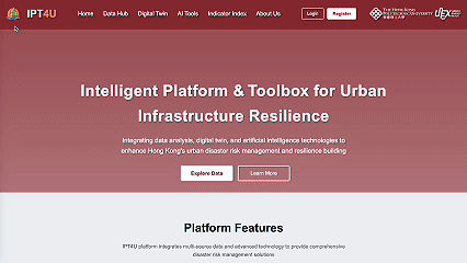
Synergy AI, real-time data, and digital twin technology to help cities prepare for and respond to natural disasters. By analyzing sensor and weather data, it predicts risks like floods or heatwaves, sends early warnings, and guides emergency actions. A resilience index and simulation tools also support long-term planning and cross-agency coordination.